News

Congratulations to Bresciani, Giardino and team for Most Downloaded Publication!

Remote Sensing just announced the most downloaded manuscript is

#WaterQuality Retrieval from #Landsat9 (OLI-2) Imagery and Comparison to #Sentinel2 by Milad Niroumand-Jadidi, Francesca Bovolo, Mariano Bresciani, Peter Gege and Claudia Giardino
👉 Read the full article: https://lnkd.in/gdyR9bNb

Read their linked in Post here: https://www.linkedin.com/posts/remote-sensing-mdpi_mostdownloaded-waterquality-landsat9-activity-7110189918651355136-TdfS?utm_source=share&utm_medium=member_android


GEO AquaWatch Releases New Communications Plan and Year 2 DEI Metric Results

Today the GEO AquaWatch Management Team and Steering Committee approved a new GEO AquaWatch Communications Plan and the Year 2 Report on our Diversity, Equity, and Inclusion Metrics.   The reports are available under the Resources > AquaWatch Documents Tabs. These efforts benefit the entire GEO AquaWatch Community and we are proud of the work that went into drafting them.  The Communications Plan was customized for GEO AquaWatch, but elements were developed in collaboration with the GEO BluePlanet Initiative and the GEO Health Community of Practice and we thank them for their assistance!

NASA ARSET Training – Introductory Webinar: Spectral Indices for Land and Aquatic Applications

October 26, November 2, & November 9, 2023
11:00-12:00 (Session A) or 15:00-16:00 (Session B) EDT (UTC-4)

This training will provide an overview of spectral indices for land and aquatic applications. Specifically, this training will begin with an introduction to the Normalized Difference Vegetation Index (NDVI), along with its calculation, uses, and prominence in Earth science. In session two, we will expand to other spectral indices primarily used in aquatic ecosystems, such as the Normalized Difference Chlorophyll Index (NDCI), Normalized Difference Aquatic Vegetation Index (NDAVI), Floating Algal Index (FAI), and Normalized Difference Turbidity Index (NDTI) for aquatic applications. In the final session we will review additional land-based indices such as the Enhanced Vegetation Index (EVI), Soil-Adjusted Vegetation Index (SAVI), and Normalized Burn Ratio (NBR). Not only will these sessions discuss the correct circumstances under which to use these indices, but participants will also take part in hands-on indices calculation over relevant study areas. Learners will work with data from Landsat 9 OLI-2, Sentinel-2 MSI and Harmonized Landsat Sentinel-2 (HLS) for indices calculation. The training will also discuss pre-calculated index products such as Terra MODIS vegetation indices and HLS vegetation indices suite and upcoming data products available based on user feedback provided to the Satellite Needs Working Group. Use cases from recent Earth Action projects (such as NASA DEVELOP) will further highlight how spectral indices can provide essential information about land and aquatic environments.

Register

GEO AquaWatch co-chairing Satellite Tools session at GOMCON 2024

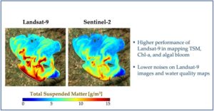
Are you a researcher developing satellite tools for assessment of water quality and/or submerged aquatic vegetation monitoring to inform decision-making? Consider submitting an abstract to the session Advances in Satellite Imagery as a Synergistic Tool for Scientific Research and Policy-making in Coastal Habitats in the Gulf of Mexico Alliance’s GOMCON 2024 in Tampa? It can be found under the Advances and Priorities for Data Management theme at this link: https://lnkd.in/e9aVPvsv

We welcome posters and talk abstract submissions from all educational and career levels. Selected scientific presentations will focus on the implementation of remote sensing imagery for informing operational decision making. Abstracts and registration are now being accepted – so please join us in Tampa next February 19-24, 2024!

Key Dates:

October 13, 2023 – Abstract Submission Deadline

Jan 12, 2024 – Early Bird Registration Ends

Feb 16, 2024 – Regular Registration Ends (onsite registration is still possible)

Session Chair: Megan Coffer, GST, NOAA and GEO AquaWatch

Co-chairs: Session co-chairs: Mark Finkbeiner (NOAA/GISP), Stacie Flood (South Florida Water Management District), Lawrence Handley (USGS), Catherine Lockwood (CNLWorld), Merrie Beth Neely (GST, NOAA and GEO AquaWatch)

Job Opportunity: US-based Senior Scientist Ocean Color, remote possible

Senior Scientist to Support Satellite Oceanography and Climatology and Ocean Color , College Park, MD 

This position is only open to qualified US citizens or those possessing a green card.  The position can be remote.

Global Science &Technology, Inc. (GST), a fast growing high technology firm is seeking mid to senior scientists for an exciting task at the Satellite Oceanography and Climatology Division at NOAA’s Center for Satellite Technology Applications and Research (STAR). This task involves broad research and application activities for ocean color remote sensing including algorithm development, testing, evaluation, and validation. Selected candidates shall work with the project leader and other members in STAR and other NOAA offices for some (or all) of the specific tasks provided below. 

Duties:  

  • Review ocean color related documents to study and understand ocean color remote sensing theory, algorithm, and applications; an understanding of instrument calibration is highly desirable.  
  • Development and applications of satellite algorithms for water properties, e.g., algorithms for biological and biogeochemical properties, IOPs, PFT, etc.   
  • Become familiar and work with the ocean color data processing system for research and algorithm development, e.g., SeaDAS, MSL12, ADL, for the data processing, data displaying, and data analyses for various satellite data sets (e.g., VIIRS, MODIS, OLCI on Sentinel-3, SGLI on GCOM-C, MSI on Sentinel-2, LandSat, PACE, etc.). 
  • Work with other non-ocean color satellite sensor data (for atmosphere and land purposes), e.g., CALIPSO data, for developing and testing new approaches for remote sensing of ocean properties.  
  • Support the identification and resolution of shortfalls in existing open ocean algorithms for application to coastal regions and identification of new applications and products from satellite measurements specifically for coastal and inland water applications.  
  • Analyze simulated and real satellite data, as well as various in situ data from ocean color and atmosphere to evaluate and improve related algorithm performance. 
  • Contribute documentation related to the project and publish scientific papers. 

Education/Experience Required:  

  • Ph.D. in Oceanography, Physics, Computer Science, and/or other Physical Sciences and Engineering. Previous work experience is required.   
  • A strong record of publications in peer-reviewed journals. 
  • Strong working knowledge of remote sensing algorithms. Understanding of satellite instrument calibration will be a plus.