
|
|
|

|
|
|
|
|
|
|
|
|
The USEPA announces this operationally live forecasting of cyanoHAB blooms! It is available here: https://www.epa.gov/water-research/cyanobacterial-harmful-algal-blooms-forecasting-research. The beta site is temporary for this season as a test, but will eventually transition into a permanent site. The project is a partnership of several US agencies and organizations.
This year’s event will be held from 26 to 30 August in Quito, Ecuador. Its theme is “Adaptándonos para un futuro resiliente, con inteligencia terrestre” or “Adapting for a resilient future with Earth Intelligence.”
In addition to the six plenary keynote sessions below, there will be a disaster risk management fair highlighting local efforts, a variety of side events and training offered, and a regional Americas Caucus meeting.
The plenary sessions for this year’s event includes:
Session 1: Disasters and Risk Management
Session 2: Achieving the Aguascalientes Commitments
Session 3: Marine and Ocean Health
Session 4: Implementation of the Post 2025 GEO Strategic Plan
Session 5: Looking toward COP28: One Health Partnerships to Accelerate Climate Action
Session 6: Security for Development
Register now via the AmeriGEO Week 2024 website and keep an eye out for more information as we get closer to the event. Already registered and can’t wait for August, check out the video our colleagues at GEO Ecuador made for a preview!
Kindly reach out to the secretariat (secretariat@amerigeo.org) with any questions.
We are pleased to inform you that the 2024 edition of the EuroGEO Workshop will take place in Krakow Poland, from 8 to 10 October 2024, at the Holiday INN, an IHG Hotel.
The EuroGEO Workshop 2024 is jointly organised by the European Commission and the EuroGEO Secretariat with the support of the Polish Space Agency (POLSA). The Key message is“COMBINE, COORDINATE, COOPERATE: Welcome to the new era of EuroGEO”
EGW24 will:
Mobilise and revitalise the EuroGEO Action Groups and harness synergies across research and EO industry around strategic focus areas.
Foster the maximisation of research & innovation impact for the benefit of end users, engaging academia and the industry.
Engage with national GEO activities, showcasing the EO expertise and synergies contributing to EuroGEO and GEO.
Facilitate peer exchanges highlighting the European contribution to GEO
Build a consensus on the adoption of a revised EuroGEO implementation plan as a contribution to GEO post-25 strategy.
On the EuroGEO workshop 2024 webpage you can find the outline of the programme (draft) as well as a list of the suggested hotels and transport means for travel from the airport to the venue.
The registrations are NOW open. Important Note! Registrations close on September 13, 2024
AfriGEO invites you to the 8th AfriGEO Symposium which will be held from 12th to 15th of August at RCMRD in Nairobi, Kenya. The theme of the symposium is, “Earth Intelligence for Africa.”
The AfriGEO symposia have been held annually since 2016. They are an opportunity for the AfriGEO Community to network, share and build meaningful collaboration and partnerships that support and address varied developmental challenges on the continent using earth observation.
The symposium will have 10 key sessions: Session 1: EO in supporting National Priorities, Session 2: EO for Disaster Risk Reduction, Session 3: EO for Agriculture and Food Security, Session 4: Post 2025 GEO Strategy, Session 5: Strengthening National Coordination, Session 6: Data and Infrastructure, Session 7: EO for Sustainable Land and Forest Management, Session 8: Africa Connect , Session 9: Innovation Lounge and Youth Session, Session 10: EO AfriGEO capacity building Fund Setup.
The AfriGEO Symposium will focus on AfriGEO’s thematic areas:
Register now through this link to attend, participate or submit your abstract (max 300 words) for the session you would like to contribute to.
Abstracts submission deadline was 30th June.


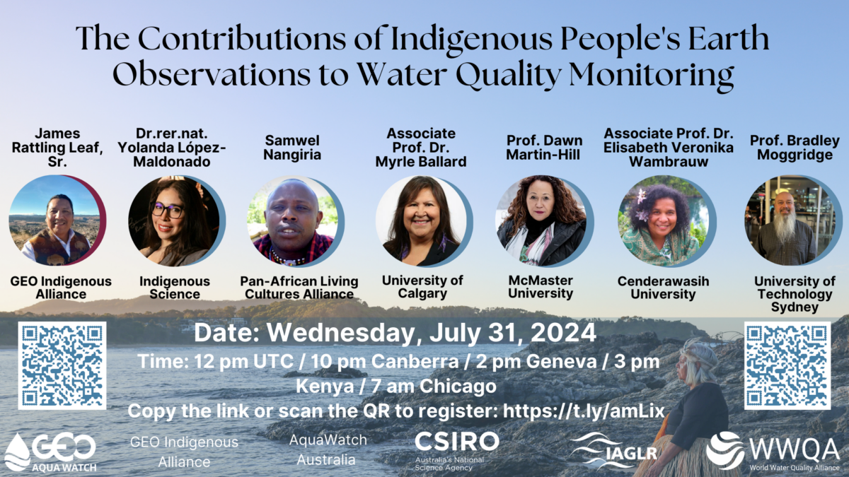
We invite you to this webinar in recognition of Indigenous People’s Day 2024 – co-sponsored by GEO AquaWatch, GEO Indigenous Alliance, CSIRO’s AquaWatch Australia, WWQA, and IAGLR. This informative 90 minute event will be moderated by James Rattling Leaf and will feature a presentation of our recent publication recommending best practices for inclusion of indigenous science, followed by Water Quality Use Cases presented by global indigenous scientists and an audience participation discussion. Use the QR code to register today or USE THIS LINK! More details on the agenda will be shared in coming days. Please help us promote this webinar by sharing it with your network!

James Rattling Leaf, Sr., GEO Indigenous Alliance, North America

Dr. Dawn Martin Hill, Professor, McMaster University, Ontario, Canada: Haudenosaunee and the story of water.
Abstract: The community-led Ohneganos research project with the Six Nations of the Grand River (Six Nations) of the Haudenosaunee Confederacy, is the largest Indigenous reserve (by population) in Canada. Six Nations community has been engaged in efforts to achieve sustainable ecosystems, health and well-being directly tied to the state of source water from the Great Lakes. As a Mohawk woman and scientist, living in my community, it is important to center the Haudenosaunee Great Law and responsibility to care for the water; this is embedded in our creation stories and the thanksgiving address. Our 5 year IK community led study with McMaster found in the climate change modeling of SN has experienced significant climate change water impacts further exacerbating water insecurity and will increase significantly over the next 30 years. By incorporating traditional knowledge and western science the community recognizes the desperate need for sustainable development in water monitoring and management. The goal is to establish a traditional ecological research Institution for training to improve our natural world’s ability to thrive so we may thrive.
Speaker Bio: Dawn is Mohawk and resides at Six Nations with her family. She was the first Indigenous cultural anthropologist in Canada and continues to break barriers in education and research. She founded the Indigenous Studies Program at McMaster University as a graduate student and recipient of a Canada U.S Fulbright Award. Her work with Elders from across Turtle Island since 1990 has influenced her development of Indigenous knowledge in academia, research, and research. She is a longtime advocate of Indigenous knowledge within her university and securing federal tri-council, Science Council’s support, and inclusion of peer reviewed funding of Indigenous knowledge and ways of knowing research. Her primary research over three decades is working with community, women, and youth to develop Indigenous ways of knowing that can be applied in resolving real world issues, Indigenous pedagogy and methodologies, developing community led strategies, holistic assessments of community wellness, traditional medicine, environmental justice and addressing improving quality of life.

Dr. Elisabeth Veronika Wambrauw, Head of the Department of Urban and Regional Planning, Universitas Cenderawasih, Indonesia: Water governance in perspective Indigenous People in Papua, New Guinea.
Abstract: I will talk about the Sambom People, Marind People, and also Naglum People of Indonesia.
Speaker Bio: Dr. Wambrauw is the head of the Department of Urban and Regional Planning at the Universitas Cenderawasih in Jayapura, Indonesia. Her research focuses on sustainable development and traditional ecological knowledge related to water and infrastructure as well as climate change.

Professor Bradley Moggridge, Indigenous Leadership & Engagement, University of Technology Sydney, Australia: The Cultural value of Water and the Importance of Understanding Water Quality for Aboriginal People.
Speaker Bio: Prof Bradley Moggridge is a proud Murri from the Kamilaroi Nation and is a researcher in Indigenous Water Science (qualifications in hydrogeology and environmental science). He is currently Acting Associate Dean – Indigenous Leadership & Engagement at the University of Technology Sydney. Until June 2021 he was the Indigenous Liaison Officer for the Threatened Species Recovery Hub under NESP. Bradley is a member of the Wentworth Group of Concerned Scientists, a Governor of WWF Australia and vice president of the Australian Freshwater Science Society. Bradley has won several awards, has presented widely and is on many committees – from local to international adding to his 25 years in water and environmental science, cultural science, regulation, water planning and management, including policy development, legislative reviews, applied research and project management. Bradley hopes to encourage future generations to pursue interests in STEM (water science), promote his ancestors’ knowledge of water and mentor emerging Indigenous scientists.
Samwel Nangiria, Pan African Living Cultures Alliance, Tanzania, Africa:
Speaker Bio: Born and raised in a typical Maasai traditional setting, I am also a socio-environmental scientist and long-term human and environmental rights defender who brings a balanced, comprehensive, and strategic approach to natural resource management and sustainable development within the setting of Indigenous communities and currently a leader of Pan African Living Cultures Alliance; an African continental movement of indigenous and local communities that aims at creating space for self-representation and determination.
Dr. Myrle Ballard, Indigenous Scholar and Associate Professor, University of Calgary, Alberta, Canada:
Speaker Bio: Dr. Ballard will tell you that she comes from a combination of three worlds. Her first is growing up on the land speaking Anishinaabe mowin as her first language and her experiential life on her reserve. Her second is Western science having earned her PhD in Natural Resources and Environmental management. Her third world is academia and government. Dr. Ballard is a professor at the University of Manitoba where her research focuses on Three-Eyed Seeing and using Indigenous language as a baseline indicator of changes in the ecosystem. Combining her lived experiences allows her to bridge and bring all sides together, while appreciating different perspectives.

NOTE: ONLY THOSE WHO CAN PROVIDE THEIR OWN TRAVEL, VISA, & ACCOMMODATION FUNDING TO STIRLING ARE INVITED TO APPLY
The University of Stirling’s Earth and Planetary Observation Research Group invite you to attend a workshop to address one of the most important questions within aquatic remote sensing, how can more people and more countries benefit from satellite-based Earth observation of water? Available satellite data and products for monitoring water quantity and water quality have advanced in the last decade, and individual countries need to grow capacity to ensure their own autonomy in benefiting from Earth observation to meet their own specific needs and agendas, whilst also supporting global initiatives, including Sustainable Development Goals. This workshop will address this critical issue by collectively exploring the challenges and opportunities to deliver a series of strategies that are specific to different global economic groups (low, lower-middle, upper-middle and high income countries) and the unique context of each group. Join us to shape a future in which all can benefit from Earth observation of water.
“Unlocking the Global Benefits of Water Quality Monitoring through Earth Observation”
Dynamic hackathon-style workshop event
28th to 30th August 2024 (Do not apply if you are unable to attend during these dates. This is an In-Person workshop only and partial attendance is not possible. Only those fully self-funded for all expenses are invited to apply)
University of Stirling, Scotland