AquaWatch’s Updated Implementation Plan for the work period 2020-2022 is now available!
Author: merriebethneely
1st Internat’l OSO Registration Closes May 15th!
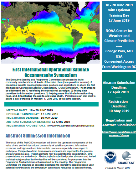


First International Operational Satellite
Oceanography Symposium, June 17-20, 2019, College Park, MD
Registration is now open and the Executive Steering and Programme Committees are pleased to invite community members from all levels of the value chain (data providers to users) of operational satellite oceanographic data, products and applications to attend the first international Operational Satellite Oceanography (OSO) Symposium. The themes to be addressed are 1) redefining the operational paradigm, 2) linking data providers to information providers, 3) helping users find the information they need, and 4) facilitating the end-to-end value chain. Participants can also elect to attend a day of training on Monday, 17 June 2019 at the same location. Abstracts are now closed. Registration closes May 15 and will not be extended! Register here!
iCOR Atmospheric Correction Plugin Available for Sentinel-3 OLCI
![]()
VITO announced this week, that after one year of work and extensive validation within the ESA iCOR4S3 project, The ICOR atmospheric correction software is now freely available to correct Sentinel-3 OLCI data! The iCOR atmospheric correction was already available for Landsat-8 OLI and Sentinel-2 MSI. Already more than 700 registered users are now able to use the same atmospheric correction for Sentinel-2, Landsat-8 and Sentinel-3. Read more to discover how it works and what’s in it for you. To learn more and download this plugin for the SNAP toolbox follow this link to VITO’s post: https://blog.vito.be/remotesensing/icor-for-sentinel-3
SECOORA Webcam Data Challenge ends 2/15!

A competition seeking contestants to transform web cameras into environmental monitoring tools that tackle real-world questions and problems.
Proposals Due February 15, 2019 | 5 PM ET
Web cameras are transforming environmental monitoring. Increasingly, scientists are analyzing video data to improve forecasts, answer questions, and support decision making.
Although camera data are being applied for environmental monitoring, they are currently underutilized. The Southeast Coastal Ocean Observing Regional Association (SECOORA) is asking the next generation of data experts to identify ways in which video footage can be applied for societal benefits.
Goals of the Data Challenge
- Encourage the use of data resources available from SECOORA (secoora.org).
- Use technologies, tools, videos, and creativity to visualize, analyze, and apply WebCAT data in order to tackle real-world questions/problems.
- Build on and enhance existing SECOORA initiatives.
- Provide students and young professionals with the opportunity to develop a competitive proposal.
More information here!
Call for Applications: Amazon Web Services Cloud Credits
The new collaboration betwee GEO and Amazon Web Services (AWS) offers GEO Member agencies and research organizations from developing countries access to cloud services to help with the hosting, processing and analysis of big data about the Earth to inform decisions for sustainable development.
Eligible government agencies and research institutions can apply for AWS credits that will enable them to build Earth observations applications that support environmental and development goals, including the Sendai Framework for Disaster Risk Reduction, the Paris Agreement and the United Nations Sustainable Development Goals.
Recipients of cloud credits through this initiative will also receive support from the GEO community and AWS experts to refine and implement their projects for the best possible results.
AWS and GEO first announced their collaboration in 2017 to support the Global Earth Observation System of Systems (GEOSS) open data platform.
Facilitating the use of data for development
National governments around the world are considering ways to respond to environmental challenges, ranging from food insecurity and water resources management, to planning sustainable and secure cities. Earth observations, using satellite imagery and in situ monitoring mechanisms, offer a way to measure, report and take action in these areas.
GEO has been supporting more than 100 UN Member States for the last decade, and offers all countries the opportunity to benefit from its community’s collective knowledge, expertise and skills to develop national Earth observations programmes.
Applications are welcome for non-commercial projects that address the GEO Work Programme, and in particular GEO’s three engagement priorities: the Sendai Framework for Disaster Risk Reduction, the Paris Agreement for Climate and the United Nations 2030 Agenda for Sustainable Development.
Use of Earth observation data from any open, free and fully accessible source is strongly encouraged in the proposed project. To discover and access free and open data, proponents are invited to use the GEOSS Portal. The GEO Secretariat will facilitate access to analysis-ready data from the Copernicus and Landsat programmes for proposals wishing to make use of this data
Criteria for applications can be found here. The deadline for submissions is 31 March 2019.
Cloud services help countries host, process and analyse big Earth data to inform better decisions and policies
An example of a multinational Earth observation project taking advantage of AWS Cloud credits is the Africa Regional Data Cube.
This recently-launched tool builds on technology developed in Australia, enabling five countries in Africa to inspect changes to any geographic area over the past 35 years. AWS has provided cloud credits for this project for three years to help the countries see the value in the tool and prototype long-term solutions.
As in Australia, the technology is expected to become a key piece of public data infrastructure that provides users with an analysis platform for satellite imagery to address key development challenges, including food security, disaster risk management, coastal erosion and urban expansion. This project is being coordinated through the Global Partnership for Sustainable Development Data (GPSDD), Strathmore University and the Committee on Earth Observation Satellites (CEOS) with support from GEO.
Philip Thigo, Office of the Deputy Prime Minister in Kenya stated:
“With a focus on supporting countries to deliver on national government policy mandates through Earth observations, GEO helps highlight and explain the value and usefulness of Earth observations for research, policy and decision making. This multi-year contribution from Amazon will fast track the awareness and understanding.”
